The drive from Zion National Park area north and east to
Bryce area showed the valley opening up.
The scenery was expansive as we made the slow climb to ~ 8,000 ft. We
passed just west of the Dixie National Forest. There are lots of varying
references to “Dixie” in this part of the state: county names, subdivision
names, roads, etc. The reference is to
the early Mormon settlers from the south part of the United States who wanted
to create “Utah’s Dixie” in this area.
We climbed about 4,000 ft from Zion area to Bryce area. Bryce Canyon is Utah’s highest elevation
National Park, and is named after Ebenezer Bryce, who declared it “a helluva
place to lose a cow”. It’s actually not
technically a canyon, but is a series of eroding cliffs on the eastern rim of a
plateau. Geologically, it’s considered
the uppermost rim of the Grand Canyon.
Saturday (March 11th) we did part of one of our Scenic
Byway drives: Highway 12 Scenic Byway from Panguitch to Bryce Canyon, but that’s
as far as we got because we made a full day out of Red Canyon and Bryce Canyon
National Park.

Red Canyon is just inside the Dixie National Forest, and is
the most amazing display of vivid red soaring walls I’ve ever seen! It’s only about 2 miles long, but it took us
over 1/2 hr to do those 2 miles because of all the photo stops!
John really liked the contrast between the plateau top (red
rock formations) and the valley floor below (grazing land).
 |
| The view, looking thru tunnel #1 towards tunnel #2 in Red Canyon |
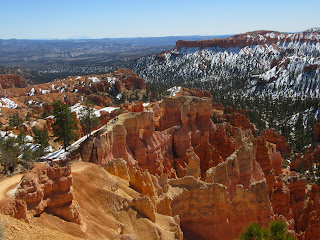
We continued on into Bryce Canyon National Park, which is one of the smallest in the state, but holy cow, does it pack a punch into a small amount of space!!
The views are pretty much top-down in this canyon. All of the trailheads are at higher elevations than the destinations of the hikes, which are at canyon bottoms. The loop trails descend into the canyon and then ascend back out. The entire Park is made up of hundreds, if not thousands of Hoodoos, but nothing like we've ever seen!
 |
| Snow in the canyon, just made for more spectacular views |
 |
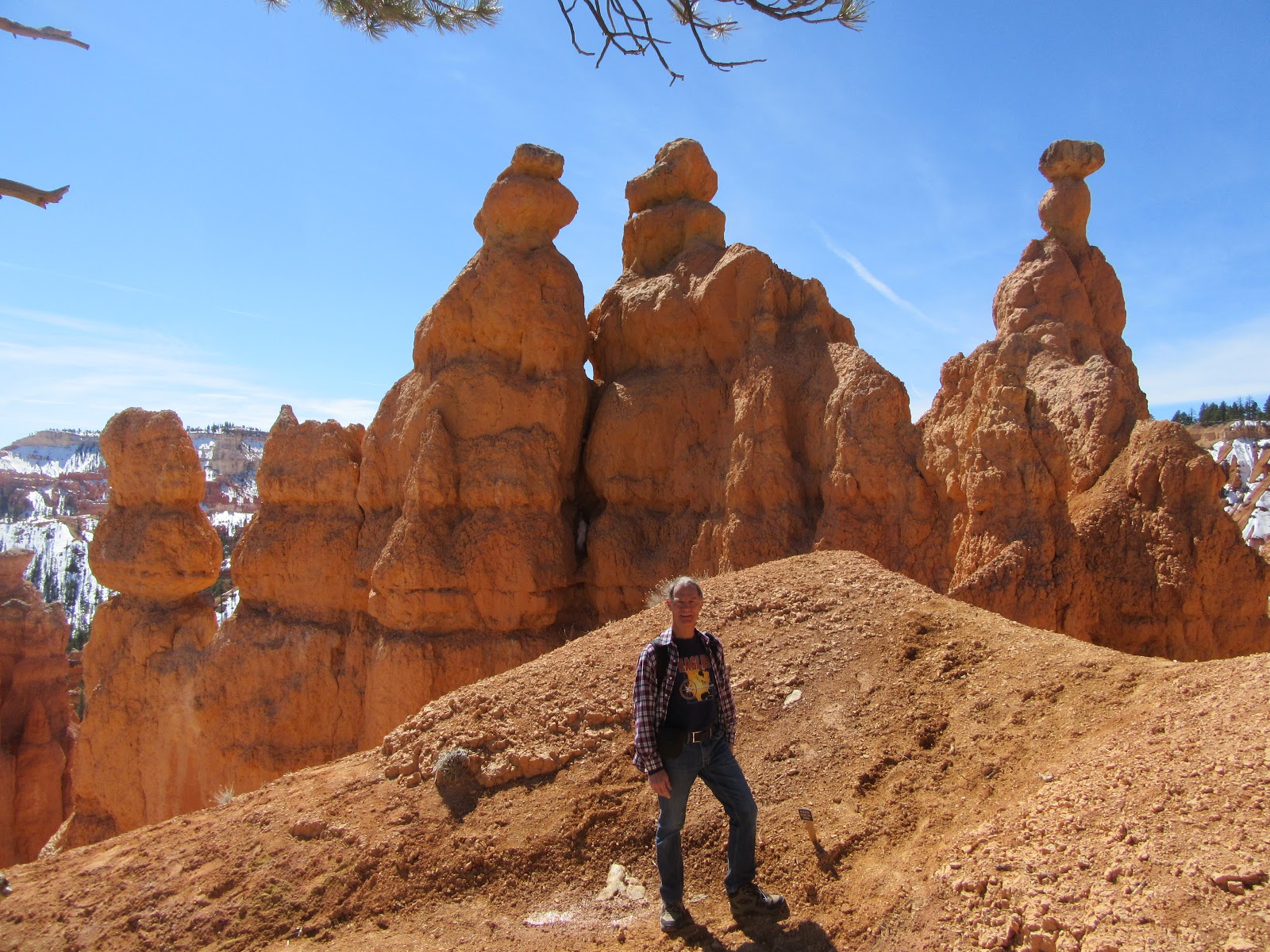
| John, with some of the hoodoos |
John commented that he found himself trying to figure out what the hoodoos looked like, and found it as enjoyable as hanging out in the backyard, gazing up at the clouds and trying to imagine what they resembled.
 |
| Dawn, with likeness of Queen Victoria in background (white hoodoo atop of her platform) |
 |
John, with "Thor's Hammer", THE hoodoo on the Bryce Canyon logo
|
 |
| Vista, from rim of canyon |
 |
| Looking down at hundreds of hoodoos |
John said this was the largest "grouping" of hoodoos he's ever seen... but they can't even be considered a "grouping" as they're continuous. It's really something to see! If you haven't been to Bryce Canyon, it should go on your Bucket List... these pictures do NOT do it justice. It's fascinating to see all the different layers of rock; the varying colours and shapes of the hoodoos. The postcards all look air-brushed, and yet the canyon really looks like that. A definite highlight of our trip.

 Red Canyon is just inside the Dixie National Forest, and is
the most amazing display of vivid red soaring walls I’ve ever seen! It’s only about 2 miles long, but it took us
over 1/2 hr to do those 2 miles because of all the photo stops!
Red Canyon is just inside the Dixie National Forest, and is
the most amazing display of vivid red soaring walls I’ve ever seen! It’s only about 2 miles long, but it took us
over 1/2 hr to do those 2 miles because of all the photo stops!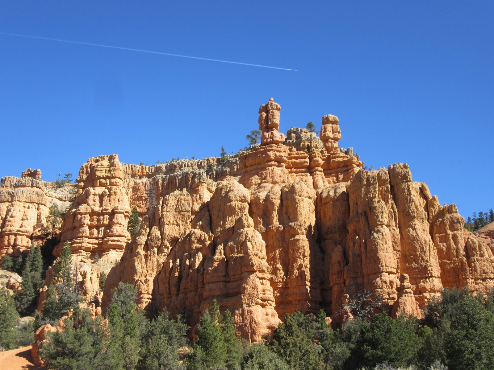


Oh wow, how incredible. We were there once, for a day - not nearly long enough. I need to touch the rock, and feel my feet on the ground in such places, rather than just peering down from the rim. Thanks for your super photography, and your comments, too.
ReplyDelete