Friday 31 March 2017

Canyonlands: Needles District - Day 1


Wednesday, March 29th, we moved the trailer from Moab to Monticello (pronounced “Monty-Sello” by the locals) so we could visit the Needles District of Canyonlands National Park.

Enroute, we had great views of the La Sal mountain range, which continues to gather snow and looks more and more like the Rockies every day! 


We passed kind of a neat visitor attraction: “Hole in the Rock” which is a 5,000 sq.ft. house that a fellow has carved out of the sandstone mountain!

We managed to find a very low-key RV Park in Monticello that only has 4 other trailers besides ours, and they seem to live here, so they’re gone during the day (presumably for work) and stay in their trailers at night when they get home. It’s much more sane than Moab. We can take the cats out for walks right in the RV park, and there is a golf course across the street that is not open yet and so the cats can wander the club house area and rough surrounding the putting green.

Thursday (March 30th) John and I drove over to the 2nd district of Canyonlands National Park, called “the Needles”. It is an area that is known for it’s red and white “striped” pinnacles, but it is vast and has much more geology than the “Needles” to admire.
Climbers on rock wall
We did a scenic drive from our book that took us from Monticello up into the Abajo mountains, which are volcanic in origin, and didn’t have as much snow as the La Sal range. The weather forecast was for snow Thurs night, so we thought it a good opportunity to see them! The Abajo scenic backway rejoins the highway enroute to Canyonlands, and we stopped and watched some climbers scaling the red rock walls just outside the Park.


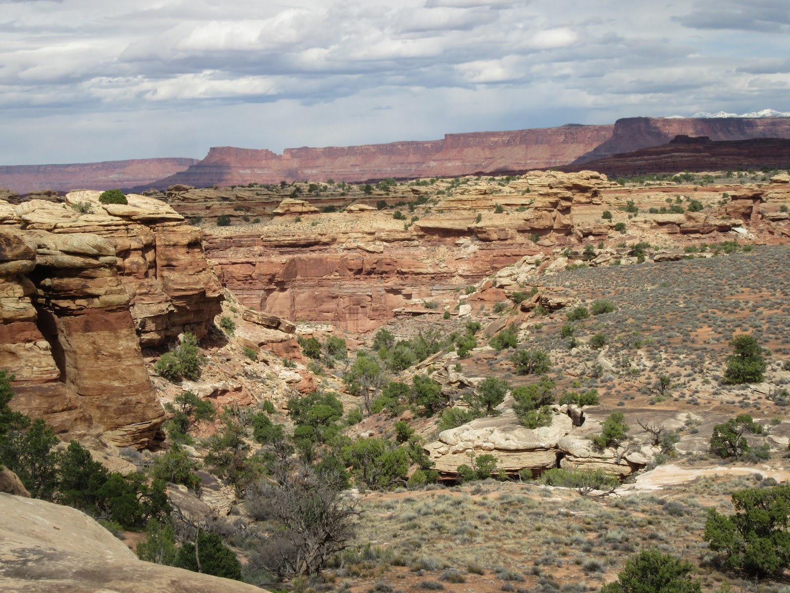
We did the scenic drive through the Park, as well as four of their viewpoint hikes, which totalled about 4 miles and so was do-able with the time we had.

John commented that it was very cool to be hiking about 1,000 ft lower than where we were at Island in the Sky, and that the views were nice, but not extraordinary like we’ve seen in other Parks. Personally, I think he’s getting desensitized to all this grandeur and beauty…


I think the views are gorgeous! I especially love the varying colours in the rock. This Park is a good combination of some of the other Parks we’ve been to: the red rock walls of Zion, the white Navajo dome rock of Capital Reef and the Entrada sandstone that forms natural bridges and arches, as in Arches National Park. Canyonlands has it all!


Island in the Sky (larger mesa in background)


I thought it was very neat to look across the canyon at Island in the Sky and Dead Horse State Park which are only 9 miles away as the crow flies, but over 100 miles away by road!

We were able to see the Grand Viewpoint where we had lunch and felt like we were at the top of the world.


Desert Paintbrush
 
"Needles", pinnacles formed by a dozen events of ebb and flow of inland sea


It was MUCH warmer in Canyonlands than in Monticello and at one point, I had to layer down while we were hiking. 

But… the black clouds rolled in and we knew the snow storm was approaching. We got back to Monticello in time to get the cats out for about 20 minutes before the winds kicked up and the storm blew in.


This is what we got up to Friday morning (March 31st)… We couldn't get Tawny outside... Sam was out for about 3 minutes.


View from our bedroom window

Thursday 30 March 2017

Moab, Utah

Sam, sitting in thick bush (which is his favourite thing)
We stayed in the town of Moab (southeastern Utah) for 4 nights while we toured the Arches National Park.

Moab was named (by the Mormon settlers) for a biblical reference to a remote desert land that lay beyond Jordan.  To me, it has the feel of Banff.  Certainly, not the same "look" (other than the volume of tourists) but it "feels" the same to me - a bustling little beehive of activity, organizing tours for avid outdoor adventurers.


Sam, checking out a church side lot

The highway runs right though town, and is jam-packed all day every day. We quickly learned the side roads that got us around town without being on the actual highway.  It was a bit too "zoo-ey" for John.  He liked Panguitch (and Torrey) a whole lot better!

Tawny, pretty well camoflauged with the gorgeous yellow bush
The campground was full of dogs and kids (and bicycles), so cat walks in the RV Park were out of the question.  We took the cats to several different places along 2 different creeks so they had their daily outdoor adventures.


John and I went out for dinner to a lovely Thai place ("Singha").  It was the first meal out for us since we left Long Beach, and was a nice change.  We're really enjoying our home cooked meals in the trailer, mind you, and have gotten particularly good use out of the small slow cooker that we brought with us.  We need power for that, of course, but we've done several amazing slow cooked dinners on long hike days.  It's so wonderful to come home to dinner smelling fantastic and being ready to eat when we're tired and hungry.  We're also getting much out of our Spiralizer. We've made butternut squash spaghetti, as well as sweet potatoe and zucchini noodles.

Sam & Tawny, exploring a trail beside Mill Creek
We haven't had reliable access to meats, fresh produce nor wine (!!) since we left St. George in SW Utah (weeks ago!!) St. George was a metropolis compared to everywhere else since.  When we find a good grocery store (or State Liquor Store) we stock up.  We learned that the hard way.


Tawny, motoring along a well-marked path along the creek.

Moab is surrounded by canyon walls so it's very protected and much warmer than other places around. Consequently, spring was in full bloom in Moab.

Everywhere else we're planning on visiting is forecasted to have winter weather warnings and advisories.  It was nice to experience spring (while it lasted)!


Arches Nat'l Park - Day 3: Devil's Garden and Windows Section

Dawn & John - in front of "Partition Arch"
Tuesday, March 28th was our 3rd day in Arches National Park. This has been a bit of a challenge for John. It could be that it is Spring Break in Canada (and maybe in the States too) but the crowds are really something this week and it doesn’t endear the Park to John… We waited over ½ hr to get through the Park gates (which is pretty typical for the other days we’ve visited). Today was all about doing the 2 things that the Park Ranger (Lee) recommended to us when we got our Fiery Furnace hiking permit. He said these 2 things were really “what the Park is about”. So, what the heck. We planned our day around Lee’s recommendations.

We did a 7.2 mile hike through "Devil's Garden" and a 3/4 mile hike up to the "Double Arches" in the Windows Section of the Park (about 1/2 hr drive from the Devil's Garden).
 
The crowds, heading into Devil's Garden
John, bundled up!!!  Brrrrrr....
It was certainly a different experience than yesterday! First of all, it was about 10 deg C cooler than it was yesterday. We both had on all our layers of clothes and it was still chilly.  It drizzled for the first hour or so of our hike then the rain stopped and it was easier to take pictures!  

Devil's Garden is an area in the Park that is wild and untamed.  Arches is uplifted and therefore has formations that don’t exist anywhere else because of the Moab Fault.  The Devil’s Garden area is fractured by a salt uplift which creates the fins, but they’re not as expansive nor as close together as in Fiery Furnace and so a trail has been created in order to see a half of a dozen arches that are “features” in the park. 


It's my opinion that this was the most challenging hike that we've done this whole trip.  A little over 7 miles took us almost 4-1/2 hrs, which is quite a bit off our normal pace.  John commented that the trail was not as well directed as it could have been. We spent a bit of time trying to figure out where the trail went a couple of times!  The masses of people disappeared after the first arch and we were on our own for the most part.  The trail markers were pretty well non-existent, and when you're hiking on rock (vs sand which has foot prints) that is an issue.  

Sandstone fins
This hike had some VERY difficult upslope scambles (which I'm thankful we did going UP vs DOWN, thanks to Lee's recommendation).  There was a long line of hikers waiting to navigate their way down the slope in one particular section. We just worked around them on our way up.

Line up of hikers trying to get DOWN the slope.
Unfortunately, there are only 3 ways to navigate the fins themselves … around the base of them in the sand washes, walking the top of them (which has a couple hundred feet drop offs on both sides) or a combination of both of those (which involves ascents and descents).  The Devil’s Garden loop hike – which is a little over 7 miles long – is a combination of all 3 of those.  John likens walking on the top of the fin to walking on a submarine that is 300 feet tall with no water underneath it.  But factor in the 40 mile/hour wind that we had and it becomes a bit hair-raising.  AND for the second day in a row, we wished we had better shoes!!

John, in front of "Private Arch" on the primitive part of the trail
But... aside from the journey TO the arches, the arches themselves were really something to see. This particular hike has a BUNCH of different looking arches that, I think, make the journey worthwhile.


"Double O Arch"; note the smaller hole below the larger one


Black Arch Overlook - Black Arch looks like a tunnel below


Partition Arch with lovely view though it.


One of my favourites - "Navaho Arch" with Utah Juniper behind

Landscape Arch - over 300 ft span (largest in world); 11 ft thick at smallest point... not long for the world


 We had lunch at Dark Angel rock formation, which was a bit lucky as this particular column helped put us back on the right trail later in the day as we knew what it looked like and John was able to orient us based on where it was.  We love Dark Angel!!


Panoramic view of the fins and red sandstone rock walls

We rejoined the main trail (and the people) at a particularly steep spot!


Fiery Furnace area, in the distance

We travelled from the Devil's Garden section to the Windows section of Arches park, and it was absolutely amazing.  I could stand in any one spot, spin 360 deg and see arches everywhere I looked.  I would have liked to have spent more time in that area of the Park, but we were out of time.  There is construction going on (mostly road construction) and so the Park closes at 7 pm each night right now.  So, depending on where you are, you may have to be leaving the parking lot at 6 pm, or 6:15 or 6:30.  There are Park Rangers posted at the various parking lots, making sure people don't get on to the trails too late in the day.  Frankly, we're tired by that time of the day and ready to be exiting the Park, but there was a short (less than a mile) hike I totally would have done had we had more time. 

As it turned out, we just had time to do the hike to the Double Arch, which was featured in the first Indiana Jones movie. It was totally amazing; one of the highlights for me.  It should be called "Triple Arch" because there's really 3 spans that are separated by peeks at the sky.  If you look closely, you can see people hiking up to the base of the spans... again, they look like ants.  This thing is immense.  And gorgeous.


We exited the Park for the last time after the Double Arches hike, and I took a picture of a rock formation that I had named "Nefertiti" on the first day we drove in... Had to include "her" in the blog.  I said goodnight to her every time we left the Park...

Arches Nat'l Park - Day 2: Fiery Furnace and Delicate Arch


This is what the area looks like (from above)

Monday, March 27th, we spent the day in Arches National Park, mostly doing the 2 things that had been recommended to us by people we’ve spoken with. And we had a great day doing them!

We started by obtaining a hiking permit (the day before) to enter an area of the park known as “the Fiery Furnace”. It is a series of giant rock “fins” or walls that are aligned northwest-southeast and create a maze of slot canyons and (mostly) dead ends. 

John, on our way up one canyon (which was a dead end)


The hiking permit allows you all day access to that area and you create your own “hike”, which is mainly a rock-climbing exercise. The object is to find areas of interest, such as hidden arches and slot canyons, and not follow any trail markers or anyone else’s tracks – which is easy to do because there are no trail markers and precious few tracks, and the ones we found didn’t lead anywhere anyway! It is a VERY different experience than any other hikes we’ve done. It reminded me of being a kid and just scrambling around on rocks at the beach or in the mountains, trying to find somewhere “to go”. It’s exactly like that in the Fiery Furnace. We hit lots of dead ends and had to retrace our steps and try again. We climbed thru one slot canyon to the top of the fin and had great views of the whole Arches park. 


This area had a natural bridge (mid pic) and we found a slot canyon off of it

This was the fin we ascended, and that is our route!
We had to be careful when we were on top of the fins as we had already learned that there are only certain places where you can get in (or out!) and we didn’t want to drop into a canyon that dead-ended and have to climb back up on top. So we had nature markers (odd trees or rock formations) to track our route along the top (you aren’t allowed to leave any markings or cairns).  We made it back out!

John thought the whole thing was really cool: it was a fun place to scramble around in, the “fins” were different than what we’ve encountered so far in Utah, and it was fun to discover places that others may not have (and great to be in a place that wasn’t crawling with people!). There are only 75 people allowed into the Fiery Furnace per day in an attempt to create an opportunity for exploration and solitude.

On our way UP!!


Some of the washes (sandy bottoms) had gorgeous greenery


Dawn with our first arch!  Yay!!


This arch, which we named "Peek-a-boo" was our greatest find!

My little Mountain-Goat-Honey-Bunny!!! Coming back down.


John, looking at the fins.  I love this pic b/c it shows the "desert varnish" on the rock on the left.  That's what the indian peoples etched into to create petroglyphs.  It's essentially just staining from evaporation of  water that crossed the rock.

We're coming back to do this!!! The boulders are about 6' high each

We found an amazing rock pile mid-afternoon that we wanted to climb and explore and see where it took us… but alas, we had another hike planned for the day, so we exited the fins and ended our Fiery Furnace adventure. We both agreed that we would love to return and do it again (and try to find that rock pile) but we need better shoes!!!

And John needs more hand cream... his hands cracked and bled from the dryness of the rock and the exertion!


Our next adventure took us to the "signature" arch in the Arches park.  It's called "Delicate Arch" but there's nothing "delicate" about it.  It's the arch that is the symbol of Utah: it's on the Centennial automobile license plates and the cover of most brochures for National Parks.  Recognize it??  The La Sal Mountains are in the background, and if you look really closely, you can see people underneath the arch (hint: they're tiny and look like ants).  The arch is gigantic. There is a natural ampitheatre that forms just below the arch, and there was a gazillion people sitting in it, looking at the Arch.  We definitely were NOT in the solitude of the Fiery Furnace anymore!!  This was not John's favourite hike.  He said it had interesting topography and an anti-climactic arch.  I liked it and think it's a "have to see".

We hiked down from the Delicate Arch and took a secondary trail over to some petroglyphs, and it was really something to see!  They were MUCH more visible and interesting than the ones we saw at Capital Reef.  We had a great (full) day at the Arches...


Sunday 26 March 2017

Arches Day 1: Scenic Drive and Overlooks

The road from Horsethief Canyon to Moab, UT showed many signs of spring.  For the first time in our trip, the foreground was not dead (looking) trees!  There is actually a green tinge to the trees now which makes for much more interesting pictures.


Moab is a main town in this area of the state.  It is named after a biblical reference to a sea in Jordan, and it is certainly a "sea" of tourists!  There is only one way in and one way out, and both are lined with trailers and cars and trucks, all pulling ATV's and bikes.  It's a happening place!


Spring blossoms on tree in our campground
We are staying in a private campground, right in Moab, that is a little zoo-ey but it has wifi and power and water, all of which we need at this point after 4 days in the BLM dry camping area.

The Moab fault, that shows the difference in stratigraphies left to right

 John says the Moab fault is interesting because it exposes formations that don't exist elsewhere.  It definitely sets the stage for Arches National Park! We're seeing different rocks here than other Utah state parks.  John was not happy with the long line up of cars/trucks/RV's trying to get into the park.  He mentioned that 20 mins is the longest time we've ever waited to get into a National Park... in any country!  It was worth it...  We did the 17-mile scenic drive through the Park, along with several short walks and overlooks that featured some of the main attractions in the Park.  This is a mix of Look Up and Look Down views here; it's mostly Look Ups...

The 3 Gossips, Sheep Rock and Organ Rock (L-R)


The La Sal mountains, still covered in snow. Gorgeous.


Great shot of the different colours in sandstone; the white is "bleached" of iron.


Balanced rock... 3500 TONS of rock, perched on a stone platform


Sand Dune Arch, with scar from recent (2016) rock fall to left of us.


Skyline Arch


Pine Tree arch
Tunnel Arch


Lovely early bloomers (that look like Broom to me)
We bought a permit for a hike into the Fiery Furnace area of Arches for tomorrow. There are no designated trails; just slickrock and a bunch of rock walls ("fins") to navigate through.  It's a free-form hike and a different experience.